


Maps & Transportation
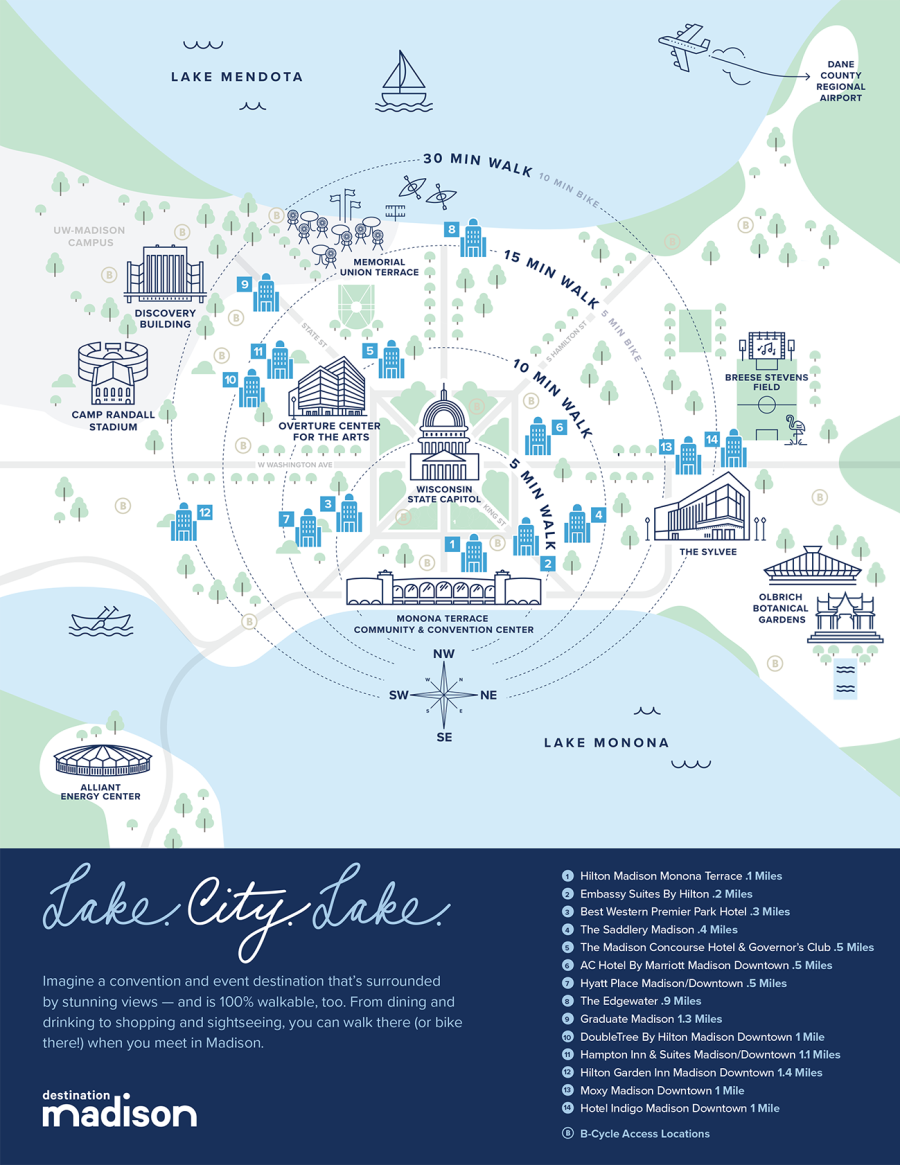
Airport to downtown in less than 15 minutes. 525 e-bike rentals across 100+ BCycle stations. Lake views instead of traffic jams. Here in Madison, you'll find a compact, culturally vibrant downtown that's walkable, safe and oh-so-easy to navigate.
Our transportation tips will help you get here—and navigate the isthmus once you've arrived.
Ready to go? Book your flight to Madison and hotel now.
GETTING TO MADISON
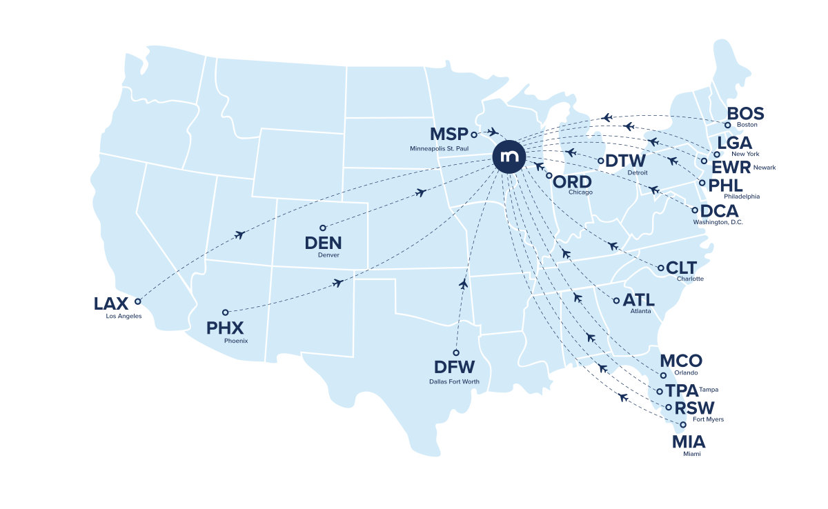
By Plane (direct flights)
Dane County Regional Airport (MSN)
Dane County Regional Airport (airport code MSN) is minutes from downtown Madison and offers more than 95 daily arrivals and departures. A growing list of direct, non-stop service flights makes getting to Madison easier than ever.
Exciting update: Delta Air Lines will launch new daily nonstop service between Madison and Boston Logan International Airport (BOS) starting June 7 and American Airlines will also offer a daily nonstop flight between MSN and BOS starting June 18.
Once you arrive, it takes less than 15 minutes to get to downtown hotels, Monona Terrace Community & Convention Center, Alliant Energy Center and the University of Wisconsin–Madison.
*Routes and flight availability frequently change. Please visit the Dane County Regional Airport website for the most up-to-date information.
Another option is Wisconsin Aviation, Inc., the state's largest, full-service, fixed-base operator and provider of general aviation services, including charter flights and aircraft rentals.
 By plane (outside of Madison)
Flying into another city? Getting to Madison from Chicago and Milwaukee is easy. Hop on a Van Galder bus right from Chicago O' Hare or a Badger Bus if you're getting here from the Milwaukee Mitchell International Airport.
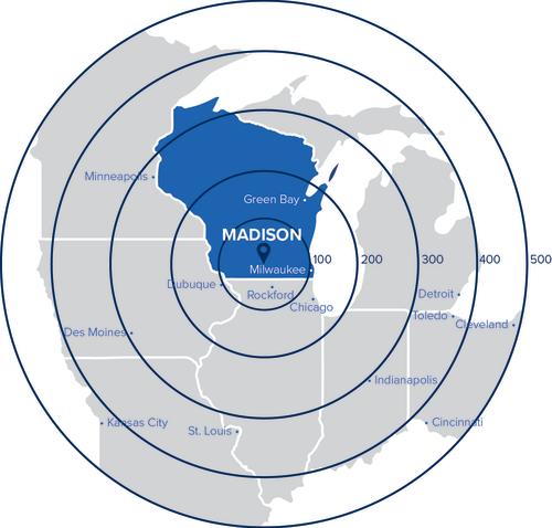
By Car
- From Milwaukee: 79 miles, 1½ hours
- From Dubuque: 91 miles, 1¾ hours
- From Chicago: 147 miles, 2½ hours
- From Green Bay: 140 miles, 2½ hours
- From Minneapolis: 273 miles, 4½ hours
- From Des Moines: 292 miles, 4¾ hours
- From St. Louis: 359 miles, 5½ hours
GETTING AROUND MADISON
By Car
Convenient on-site car rental at the Dane County Regional Airport is available from the following companies: Alamo, Avis, Budget, Enterprise, Hertz and National.
Rideshare options, including Lyft and Uber, are available throughout Madison. Limousines and taxis, including Gallant Knight Limousine and Union Cab, are also great options. You can find pick-up locations on the airport's website.
Electric Charging Stations
Madison Gas and Electric's more than 50 public charging stations are powered by 100% renewable energy. Stations can be found across the Greater Madison Area. Find MG&E charging stations.
By Bus
Metro Transit, Madison's public bus transportation, has been updated for convenience and greater accessibility. Updates include a new, fully electric Bus Rapid Transit (BRT) route with larger buses, a brand new tracking system, convenient payment options (Mastercard, Visa, Apple Pay, Samsung Pay and Google Pay) and more!
Accessibility features include automatic bus stop announcements, spacious crosswalks, pedestrian lights that provide plenty of time to cross to stations, plus visual and audible cues that signal when it's safe to cross. Real-time updates on bus arrivals are displayed and played audibly. Two wheelchair securement areas are at the front of the bus. Ticket vending machines with Braille instructions and audible information are located on BRT platforms. Learn more about BRT.
List of bus/charter companies
Madison Metro Bus System
Long-Distance Intercity Bus Service
By Bike
One of the most convenient, scenic and eco-friendly ways of traveling in Madison is by bike. We're a Platinum-level Bicycle Friendly Community due to our bike-friendly infrastructure, safe paths, abundance of e-bike rental stations and modernization efforts. Want to rent a bike close to your hotel or convention center? Madison BCycle offers 100+ e-bike rental stations throughout the city. Just download the app, unlock your e-bike and go!
Destination Madison also offers an exclusive discount for 1/2 off a single BCycle ride. All you need to do is sign up for Madison By Bike (it's free!) and get pedaling.
On Foot
Gold-rated for walkability. #2 Best State Capital for Safety by WalletHub. Our leisure and business travelers love Madison for its walkability and easy access to iconic cultural landmarks, local shopping and outdoor adventures.
MAPS & NAVIGATION
Visitor Map (PDF)
Downtown Madison Map & Guide
City of Madison Bike Map & Guide
City of Madison Parking Garages & Lots